THE air at 13,000m above the equatorial Pacific 1,600km south of Hawaii is a shimmering gumbo of thick storm clouds and icy cirrus haze, all cooked up by the overheated waters below.
In a Gulfstream jet, researchers with the US National Oceanic and Atmospheric Administration are cruising this desolate stretch of tropical ocean where the northern and southern trade winds meet.
This is the heart of the strongest El Niño in a generation, one that is pumping moisture and energy into the atmosphere, roiling weather worldwide.
The aircraft makes its way on a westward tack, steering clear of the worst of the disturbed air to the south. Every 10 minutes, on a countdown from Mike Holmes, one of two flight directors, technicians in the rear release an instrument package through a narrow tube in the floor.
Slowed by a small parachute, the devices, called dropsondes, fall towards the water, transmitting wind speed and direction, humidity and other atmospheric data back to the aircraft.
The information, parsed by scientists and fed into weather models, may improve forecasting of El Niño’s effect on weather by helping researchers better understand what happens here, at the starting point.
"One of the most important questions is to resolve how well our current weather and climate models do in representing the tropical atmosphere’s response to an El Niño," says Randall Dole, a senior scientist at the administration’s Earth System Research Laboratory and one of the lead researchers on the project. "It’s the first link in the chain."
An El Niño forms about every two to seven years, when the surface winds that typically blow from east to west slacken.
Warm water that normally pools along the equator in the western Pacific piles up towards the east instead. The expanse of water — which in this El Niño has made the central and eastern Pacific as much as 15ºC hotter than usual — acts as a heat engine, affecting the jet streams that blow at high altitudes. That can bring more winter rain to the lower third of the US and dry conditions to Southern Africa.
Aided by vast processing power and better data, scientists have improved the ability of their models to predict when an El Niño will occur and how strong it will be. In June, the consensus among forecasters using models developed by the administration, as well as other US and foreign agencies and academic institutions, was that a strong El Niño would develop later in the year, and it did.
But scientists have been less successful at forecasting an El Niño’s effect on weather. This year most models have been less certain about what it will mean for parched California.
Much of the state has received higher than usual precipitation, but it is still unclear whether southern California will be deluged, as much as it was during the last strong El Niño, in 1997-98.
Anthony Barnston, chief forecaster at the International Research Institute for Climate and Society at Columbia University, who has studied the accuracy of El Niño modelling, says dynamical models, which simulate the physics of the real world, have recently done a better job in predicting whether an El Niño will occur than statistical models, which rely on comparisons of historical data.
With a dynamical model, Barnston says, data representing current conditions is fed into the model. "You plug it in and you crank it forward in time," he says. This can be done dozens of times, tweaking the data slightly each time and averaging outcomes.
Good data are crucial. El Niño models have been helped by the development of satellites and networks of buoys that can measure sea-surface temperatures and other ocean characteristics. When it comes to forecasting El Niño’s weather effects, however, good data can be harder to come by.
That is where the administration research project aims to help, by studying a vital process in the El Niño-weather connection: deep tropical convection. The clouds that the jet cruised past were a result of this process, in which air over the warm El Niño waters picks up heat and moisture and rises thousands of metres. When the air reaches high altitudes, the moisture condenses into droplets, releasing energy in the form of heat, and creating winds that flow outwards.
Scientists know the energy released can induce a kind of ripple in a jet stream, a wave that can affect weather around the world, and that the winds generated can add a kick to a jet stream, strengthening it.
But to study convection during an El Niño, data must be collected from the atmosphere, as well as the sea surface. That is a daunting task, because the convection occurs in one of the most remote areas of the planet.
As a result, there has been little data on convection during El Niño events, Dole says, and most models, including the administration’s, have had to make what amount to educated guesses about the details of the process.
"Our strong suspicion is that our models have major errors in reproducing some of these responses. The only way we can tell is by going out and doing observations," he says.
When forecasters last year began to predict a strong El Niño, the administration’s scientists started making plans for a rapid-response programme of research.
In a way, he says, they were helped by the developing El Niño, which suppressed hurricane activity in the Atlantic last northern autumn. The Gulfstream flew fewer missions and the available flight hours, as well as extra dropsondes, were transferred to the project. In addition to the jet — which is also equipped with Doppler radar to study wind — the programme is launching other sondes, from a ship and a small atoll near the equator. A large remotely piloted aircraft from Nasa, the Global Hawk, has also been enlisted to study the Pacific between Hawaii and the mainland.
The Gulfstream flight was the researchers’ fourth, out of nearly two dozen planned over the next month. The day begins at Honolulu airport when Ryan Spackman, the other lead investigator, and administration colleagues sit down for a weather briefing with Dole and other scientists at the agency’s offices in Boulder, Colorado.
Data start streaming in almost immediately once a dropsonde leaves the aircraft, and are displayed in real time in the cabin on computer screens including the one manned by Richard Henning, the other flight director.
Henning, a meteorologist, makes sure the data are clean — with his practised eye, he can quickly tell if a sensor has malfunctioned or the sonde has otherwise provided unusable data — before sending it off in several forms including a condensed format that can be fed immediately into models around the world.
Crew members make sure all the aircraft’s electronics are running properly and monitor the Doppler radar. Holmes, Spackman and the aircraft commander, Ron Moyers, talk from time to time about course changes to get closer to the convection for better data.
Henning and Spackman take time to look over some of the dropsonde data. They see winds coming out of the top of the convective cell and blowing towards the northwest. Earth’s rotation, Spackman says, would make that wind curve to the east, where it would join the Pacific jet stream that was affecting the West Coast.
Spackman seems pleased despite the change in plans. "We did a lot of good science today," he says.
NYTimes.com
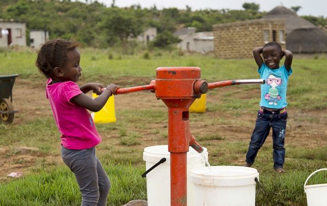
Children pump water at the last tap with running water in drought-stricken Masotsheni, north of Durban, last month. Scientists are flying into the source of El Niño, causing the drought, to collect data. Picture: REUTERS
THE air at 13,000m above the equatorial Pacific 1,600km south of Hawaii is a shimmering gumbo of thick storm clouds and icy cirrus haze, all cooked up by the overheated waters below.
In a Gulfstream jet, researchers with the US National Oceanic and Atmospheric Administration are cruising this desolate stretch of tropical ocean where the northern and southern trade winds meet.
This is the heart of the strongest El Niño in a generation, one that is pumping moisture and energy into the atmosphere, roiling weather worldwide.
The aircraft makes its way on a westward tack, steering clear of the worst of the disturbed air to the south. Every 10 minutes, on a countdown from Mike Holmes, one of two flight directors, technicians in the rear release an instrument package through a narrow tube in the floor.
Slowed by a small parachute, the devices, called dropsondes, fall towards the water, transmitting wind speed and direction, humidity and other atmospheric data back to the aircraft.
The information, parsed by scientists and fed into weather models, may improve forecasting of El Niño’s effect on weather by helping researchers better understand what happens here, at the starting point.
"One of the most important questions is to resolve how well our current weather and climate models do in representing the tropical atmosphere’s response to an El Niño," says Randall Dole, a senior scientist at the administration’s Earth System Research Laboratory and one of the lead researchers on the project. "It’s the first link in the chain."
An El Niño forms about every two to seven years, when the surface winds that typically blow from east to west slacken.
Warm water that normally pools along the equator in the western Pacific piles up towards the east instead. The expanse of water — which in this El Niño has made the central and eastern Pacific as much as 15ºC hotter than usual — acts as a heat engine, affecting the jet streams that blow at high altitudes. That can bring more winter rain to the lower third of the US and dry conditions to Southern Africa.
Aided by vast processing power and better data, scientists have improved the ability of their models to predict when an El Niño will occur and how strong it will be. In June, the consensus among forecasters using models developed by the administration, as well as other US and foreign agencies and academic institutions, was that a strong El Niño would develop later in the year, and it did.
But scientists have been less successful at forecasting an El Niño’s effect on weather. This year most models have been less certain about what it will mean for parched California.
Much of the state has received higher than usual precipitation, but it is still unclear whether southern California will be deluged, as much as it was during the last strong El Niño, in 1997-98.
Anthony Barnston, chief forecaster at the International Research Institute for Climate and Society at Columbia University, who has studied the accuracy of El Niño modelling, says dynamical models, which simulate the physics of the real world, have recently done a better job in predicting whether an El Niño will occur than statistical models, which rely on comparisons of historical data.
With a dynamical model, Barnston says, data representing current conditions is fed into the model. "You plug it in and you crank it forward in time," he says. This can be done dozens of times, tweaking the data slightly each time and averaging outcomes.
Good data are crucial. El Niño models have been helped by the development of satellites and networks of buoys that can measure sea-surface temperatures and other ocean characteristics. When it comes to forecasting El Niño’s weather effects, however, good data can be harder to come by.
That is where the administration research project aims to help, by studying a vital process in the El Niño-weather connection: deep tropical convection. The clouds that the jet cruised past were a result of this process, in which air over the warm El Niño waters picks up heat and moisture and rises thousands of metres. When the air reaches high altitudes, the moisture condenses into droplets, releasing energy in the form of heat, and creating winds that flow outwards.
Scientists know the energy released can induce a kind of ripple in a jet stream, a wave that can affect weather around the world, and that the winds generated can add a kick to a jet stream, strengthening it.
But to study convection during an El Niño, data must be collected from the atmosphere, as well as the sea surface. That is a daunting task, because the convection occurs in one of the most remote areas of the planet.
As a result, there has been little data on convection during El Niño events, Dole says, and most models, including the administration’s, have had to make what amount to educated guesses about the details of the process.
"Our strong suspicion is that our models have major errors in reproducing some of these responses. The only way we can tell is by going out and doing observations," he says.
When forecasters last year began to predict a strong El Niño, the administration’s scientists started making plans for a rapid-response programme of research.
In a way, he says, they were helped by the developing El Niño, which suppressed hurricane activity in the Atlantic last northern autumn. The Gulfstream flew fewer missions and the available flight hours, as well as extra dropsondes, were transferred to the project. In addition to the jet — which is also equipped with Doppler radar to study wind — the programme is launching other sondes, from a ship and a small atoll near the equator. A large remotely piloted aircraft from Nasa, the Global Hawk, has also been enlisted to study the Pacific between Hawaii and the mainland.
The Gulfstream flight was the researchers’ fourth, out of nearly two dozen planned over the next month. The day begins at Honolulu airport when Ryan Spackman, the other lead investigator, and administration colleagues sit down for a weather briefing with Dole and other scientists at the agency’s offices in Boulder, Colorado.
Data start streaming in almost immediately once a dropsonde leaves the aircraft, and are displayed in real time in the cabin on computer screens including the one manned by Richard Henning, the other flight director.
Henning, a meteorologist, makes sure the data are clean — with his practised eye, he can quickly tell if a sensor has malfunctioned or the sonde has otherwise provided unusable data — before sending it off in several forms including a condensed format that can be fed immediately into models around the world.
Crew members make sure all the aircraft’s electronics are running properly and monitor the Doppler radar. Holmes, Spackman and the aircraft commander, Ron Moyers, talk from time to time about course changes to get closer to the convection for better data.
Henning and Spackman take time to look over some of the dropsonde data. They see winds coming out of the top of the convective cell and blowing towards the northwest. Earth’s rotation, Spackman says, would make that wind curve to the east, where it would join the Pacific jet stream that was affecting the West Coast.
Spackman seems pleased despite the change in plans. "We did a lot of good science today," he says.
NYTimes.com


Change: 0.96%
Change: 0.73%
Change: 2.82%
Change: -0.03%
Change: 2.23%
Data supplied by Profile Data
Change: 0.42%
Change: 1.07%
Change: 0.96%
Change: 0.00%
Change: 0.79%
Data supplied by Profile Data
Change: -3.08%
Change: -1.53%
Change: -2.18%
Change: -2.02%
Change: -1.86%
Data supplied by Profile Data
Change: -0.31%
Change: 0.51%
Change: 1.99%
Change: 2.07%
Change: 2.66%
Data supplied by Profile Data